matthew robertson photo essay
The Bathurst Street Bridge
When I'm out in the city, there's one spot that I prefer to all others.
I have the photos to prove it.
This is the view of Toronto from the Bathurst street bridge. I have more photos taken from, of, or near this bridge than any other place in the city.

Taken from an almost identical position, this is an eight-second IR exposure. The blur is from the bridge swaying with the shock of heavy trucks and streetcars crossing behind me.

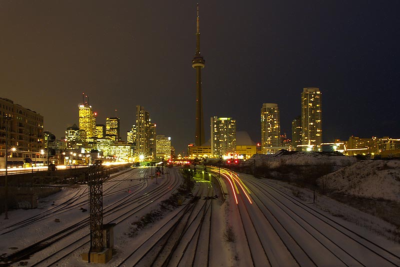
Titled "Wrath", this is my favourite image from 2005. If the city ever gets around to building the Front Street extension, whis area will be paved over and Beautified.

This is the south end of the bridge, where the Victorian ironwork is replaced by a concrete structure. The police stables are a short gallop away, and the horses are often exercised along the rail lands and under a nearby elevated expressway.

Turn ninety degrees clockwise from "Wrath" and you have "Tension". This is a view down from the side of the bridge abutment to the rail lands. The train is a long string of auto racks left on a Canadian National railway siding.

Sometimes I venture off of the bridge itself. This is a ramp leading up to it.

Beneath the bridge there's a sad end to a recreational trail that goes nowhere and does nothing. Eventually it will link to condos on the other side of the bridge that have just started construction. At least the lamps can be funny.

Here the recreational trail parallels the route of the extinct Garrison Creek, named in honour of Fort York directly to the north, and only a few dozen meters away from the original shoreline of Lake Ontario. This piece of forgotten land is an abandoned rail spur that served the local industries until a few years ago, and hosted a small wetland. It has since been drained as part of the previously-mentioned condo construction, but hopefully the spring thaw will bring the wildlife back.

More auto racks, a passing GO Train, and me. Taken beneath the bridge.

A closer detail of one of those auto racks. I've even taken a photograph of the underside of one of them.

The Union Station Rail Corridor is operated by GO Transit, which has budgeted $600 Million over the next ten years to upgrade the infrastructure between Strachan Avenue in the west to the Don River in the east. The sign saying that the corridor begins is about a kilometer inside its boundaries.

Before I worked downtown, I would ride the streetcar or my bike across this bridge. I'd look across and think, "One day I'll stop and take a photo of that..."

Where the Recreational Trail Ends. I'm sure that this will eventually be a thriving park, which means that other people will be there and I won't.

At the southern end of the bridge is a giant wall giving a history of Fort York and the city.
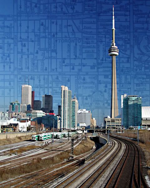
Another way of seeing the skyline. I reworked this photo and submitted it to the Toronto Guild for Photographic Art's 2005 "Our City" clinic. It won a ribbon - putting it in the top 15% of images submitted - but the judges comments told me that they'd have preferred the original.

The railing on the southern extension of the bridge in early January.
And that's my collection from 2005. Three cameras were used, producing sixteen photos that I like, including two of my five favourites of 2005. It's been a good year, with a lot of changes past and still to come. I hope I have as good a collection next December.
This is an extremely rarely updated essay site. For current photos, visit
robertsonphoto.blogspot.com
Previous Photos
TTC STRIKEThe Queen's Wharf
Jyllands-Posten Protest: Toronto
Orchids
The Bathurst Street Bridge
The Brickworks Collection, 2005
Arson
Fort George, Niagara-on-the-Lake
Barrie and Kids
Welland Triathlon
Full Archives
05.05 07.05 08.05 10.05 11.05 12.05 02.06 03.06 05.06

![]()